
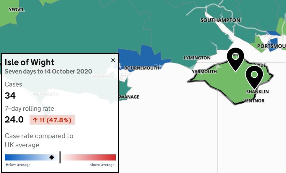
AN UPDATED interactive government map reveals where the Isle of Wight's coronavirus cases were recorded for the seven days up to October 14.
It shows the breakdown of all the Covid-19 cases in postcode areas which have reported at least three confirmed positive tests.
The Island is listed as having 24 positive cases per 100,000 people — the second lowest of any region in England and Wales, after Folkestone and Hythe (20.4).
However, because the data lags behind daily confirmed cases, a further 30 Covid-19 positives have been added to the Isle of Wight’s overall tally since October 14.

There have been 542 coronavirus cases here since the pandemic began, with a further daily update due this afternoon.
The map reveals that all Island areas included have an infection rate below the national average.
Last week, another death was included in the Isle of Wight’s figures.
The woman, who was aged in her 80s, died on September 1 and has yet to be included on the official NHS England figures.
Breakdown of Isle of Wight positive cases (October 8-14)
Sandown and Brading — 3
Ryde Central — 4
Ryde South — 3
Binstead and Wootton — 6
East Cowes and Osborne — 6
Cowes Central — 3
Total positive cases: 25.


House Rules
We do not moderate comments, but we expect readers to adhere to certain rules in the interests of open and accountable debate.
Read the rules hereLast Updated:
Report this comment Cancel